


|
|
|||
|
South East Sulawesi covers South East Sulawesi peninsula, Buton Island, Muna Island and small islands spread out at South and South East of peninsula. It's located at length wise from west to south east i.e. 3° - 6° latitude and 120° 45' - 124° 06' longitude. It borders to the north by South Sulawesi Province and Central Sulawesi Province, to the south by Flores Sea, to the east by Banda Sea and to the west by Bone Bay. The Southeast Sulawesi Province is populated by more
than 1.2 million people, in five diverse and interesting cultural
groups: the Tolaki, Morunene, Buton, Muna (locally called the Wuna),
and the Bajo.All offer the visitor a glimpse of life-styles which
have survived man's rush to modernization while using much of today's
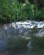
technology to their advantage. The entire province is inhabited by wonereous animals, living freely, easily seen and appreciated by visitors. Deer, Wild Pigs, Small Rodent-Like animals called Kus- Kus, Monkey, Snakes, Anoa (small Buffalo) and numerous varieties of birds abound. But the hunting of animals is forbidden in national parks and preserves and carefully controlled by local government, in other areas. The warmth of the Sulawesi people, the local flora, fauna, and untouched beaches, are the highlights of this unique loacale. It is truly one of the world's last remaining natural habitants waiting so show off for the visitor who can appreciate such natural beauty and the people who live in it.
|
|||
|
|
 |
 |
 |
